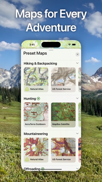
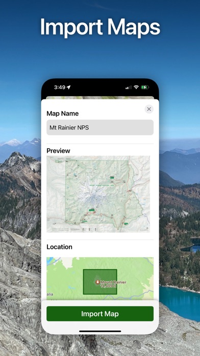
Topo Maps+

Topo Maps+

By Glacier Peak Studios LLC

  • Category: Navigation
  • Release Date: 2013-07-30
  • Current Version: 7.6.1
  • Adult Rating: 4+
  • File Size: 236.64 MB
  • Developer: Glacier Peak Studios LLC
  • Compatibility: Requires iOS 13.0 or later.
Score: 4.75807
4.75807
From 8,242 Ratings

Description

Designed and tested on real dirt, Topo Maps+ is packed with the maps & tools to plan and execute your backcountry adventure. ‣‣ MAPS FOR EVERY ACTIVITY ‣Setup your map based on your planned activity ‣‣ PLANNING TOOLS ‣ Compare and Download maps for use offline. ‣ Combine overlays to customize your map view ‣ Smart route-building tools ‣ Waypoints ‣ Print, email or share custom maps and routes ‣ Public, Private, and Hunting land boundaries ‣ Parcel Information ‣ Create teams and live-share members’ last known location ‣‣ ON-TRAIL TOOLS (Offline) ‣ View your current location ‣ All Maps and Overlays are downloadable ‣ Record your tracks - see where you’ve been ‣ Photo Waypoints - snap a pic and instantly shows on the map ‣ Progress on Trail - how much further on the trail ‣ Guide Me - to a waypoint ‣ Proximity Alerts - notify me when I’m close to a waypoint, trail, or region ‣ Line of Sight - what am I looking at? ‣ Downloaded elevation data for route-creation on the trail ‣‣ APPLE WATCH ‣ Integration with Apple HealthKit ‣Download maps directly to the watch ‣ Pan and zoom the map just like on the phone ‣ Drop a waypoint ‣ Record a track and see all of your stats ‣‣ CARPLAY ‣ Navigate to the trailhead ‣ Turn by Turn directions on USFS Roads ‣‣ NAVIGATIONAL MINDSET - helpful tips and tricks for keeping you safe in the backcountry! ‣‣ SUBSCRIPTION LEVELS: FREE level: view low resolution maps, record your tracks, and limited features Topo Maps+ Pro: high resolution maps, download maps, planning & on-trail tools, driving mode, import geospatial PDFs and TIFFS, MapBox Satellite map, US public and private land overlays, parcel and ownership contact info, game management units. ‣‣ CLOUD Sync your routes, trips, subscriptions, and waypoints between all of your iOS and Mac devices. SUBSCRIPTION PAYMENT INFORMATION Topo Maps+ subscriptions will be charged to your Apple ID account at the confirmation of purchase and/or completion of free trial. Subscription automatically renews unless it is canceled at least 24 hours before the end of the free trial or current period. Your account will be charged for renewal within 24 hours prior to the end of the current period. You can manage and cancel your subscriptions by going to your account settings on the App Store after purchase. Privacy Policy: https://topomaps.co/info/privacy Terms of Service: https://topomaps.co/info/tos Continued use of GPS running in the background can dramatically decrease battery life.

Screenshots

Reviews

  • Traveling by foot at Cinque Terre, Italy

    5
    By OAMCD
    Great walk among Unesco’s patrimonial site!
  • MUST create an account.

    1
    By Slcg
    The first thing the app asks you is to create an account. You can't proceed, review the app, or get any feel for how good it is without giving away your email address. I don't know if they track account completion, but this may account for lack of engagement.
  • broken

    1
    By Temka
    Maps don't load, app crashes
  • Tutorial

    3
    By SidneyZ
    The app seems to work ok, but figuring out how everything works by trial and error is a huge waste of time. Are there any online tutorials that we can access to see if the app even does the things we want it to do?
  • Some hiccups

    4
    By dudelilo
    First off, I have been using this app since 2017 or earlier, most for hiking in remote mountains. I started with the free version and I likes it enough to have upgraded to pro version after a few months. Overall, I love the app, it's easy to use, the high def map is very clear; overall the routes are accurate... very far and between, the tracking would act weirdly-- instead of the actual path, it would be a straight line between two points. This doesn't happen often, but when it does, it's very frustrating. This used to be my only complain. However, this year, I have noticed the map has not run as smoothly as it used , it opens a lot slower and keeps on showing the message that I was attempting to view a section that was not downloaded despite the opposite. Also, the mileage has been on average much more than my other tracking devices ( Garmin watch/ apple watch/ garmin inreach)and apps( Allatrails / Gaia GPS) . These two problems have been really frustrating, especially the map viewing glitches. Tried to find solutions on their website but in vain! Not sure if other people have experienced the same issues and what is the remedy! Otherwise, this is a nice app.
  • I like leading the pack

    5
    By Fratellos2009
    This is a great tool to have, especially if you’re planning adventure trips outdoors ,I’m able to plan are route and lead are group , I feel confident with this to get to are destination and I get to lead our group in ste SXS and not eat anybody’s dust and while I’m doing this, I’m also recording and stored the tracks in route folder I also uses on walks to see how many miles I put in Tony
  • Well done

    5
    By fefhiyefhji
    Great tool for planning hikes
  • Super App and Outstanding Customer Service

    5
    By Walkabout44
    This has been my go to app for several years. It has everything I need. Access to maps of all kinds, the ability to download for offline use, to track and trace your hike in all sorts of different ways. The user interface is very intuitive and the app has always been completely reliable. I use it primarily for hiking but also for running, biking, and even documenting sightseeing walks or drives when I travel. One of the things I like to do is to upload my hikes or travels to my computer which is easy to do, plus you can go the other direction and upload gpx or kml tracks into the app. It also gives you the opportunity for land ownership maps if you want to subscribe to it which I have found very useful. I love it! I am writing this review now because recently I had troubles with uploading some files to my computer and I sent them an email about it, figuring I would have to wait weeks or maybe longer. Instead I went out for a bike ride and when I got back, I had an email from them diagnosing the problem, fixing it, and even giving me a workaround for old files! That's the best customer service I have seen in years! So you can't go wrong with this app.
  • Garage

    1
    By prodcat
    Dot waste your time
  • Tracks are inconsistent

    2
    By Oreodont
    The app will sometimes show the route you are traveling, and other times - inexplicably- your path does not show, until the hike is completed. The help center is also not working. I’ll be cancelling the subscription.

keyboard_arrow_up